Driving to Vallico Sotto
These instructions assume (a) that you are some kind of 20th century throwback who can't operate Google maps on your phone, (b) that you have some kind of actual map, and (b) that you are
approaching Lucca on the A11 autostrada - either from Pisa or from Genova via
the coastal A12 motorway or directly from Florence. There are other approaches
into the lower Garfagnana (e.g. from Aulla, from Modena, from the Versilia
coast near Massa, from Pistoia via Bagna di Lucca) but they all involve rather
forbidding windy roads and mountain passes.. feel free to try it but you're on
your own!
PISA : If you are coming from Pisa airport, you first need to get on the
north-south A12 coastal motorway (follow the green 'autostrada' signs from
the airport). South is indicated by 'Livorno' and north by 'Genova' and
you want to go north. This is a toll motorway and you need to take a
ticket out of the automatic machine when you join the autostrada towards
Genova. Head north for about 10 minutes then take a right-hand fork to
join the lower branch of the A11 motorway heading east which will be signposted towards 'Firenze' (Florence).
FLORENCE : Get on the A11 Florence-Lucca motorway somehow (follow the green
'autostrada' signs from the airport or wherever you are) and head west.
GENOVA/A12 : Take the exit near Viareggio for 'Firenze, Lucca' and get on the
upper branch of the A11 motorway heading towards Lucca.
When you leave the motorway at Lucca (either Lucca Est or Lucca Ovest, but Est
is best) you need to pay the toll, which (from Pisa) should be 2 Euros 30 cents
or thereabouts. At Lucca Est only the leftmost toll booth has a human who can
give you change.
So from the A11 you've taken
either of the two turn-offs for Lucca. This is a rather large city, and
you need to travel through it (there is no bypass) in order to go up the
valley of the River Serchio which heads into the mountains to the north.
If you see any signs to Garfagnana, Bagni di Lucca, Abetone or
Castelnuovo, you should follow those.. From the centre outwards Lucca consists
of an ancient mediavel heart surrounded by giant walls and lawns, then a sort of ring road, then sprawling modern suburbs. You will end up on the ring road
directly outside the mediaeval wall. Follow it round, necessarily
clockwise, until you find the turn off to the North signposted to Abetone
etc. (via del Brennero, or SS12)
Once you get through Lucca you will at first be on the right of the River Serchio. Eventually you will want to be on the left. You can cross at the following places:
(1) (RECOMMENDED) After a few miles on the SS12 there is a large roundabout next to an Esselunga supermarket - cross the bridge here by taking the third exit (like turning left..). Note - if you do this you will shortly afterwards start going through tunnels. After
the third tunnel a bridge takes you over the river again and then the road will narrow and bend to the left then to the right -
then the road forks abruptly. Make sure you take the right fork to Castelnuovo in order
to cross the river on the (new for 2007) bridge and get back on the left-hand side.
I appreciate this is confusing.
(2) Ponte a Moriano,
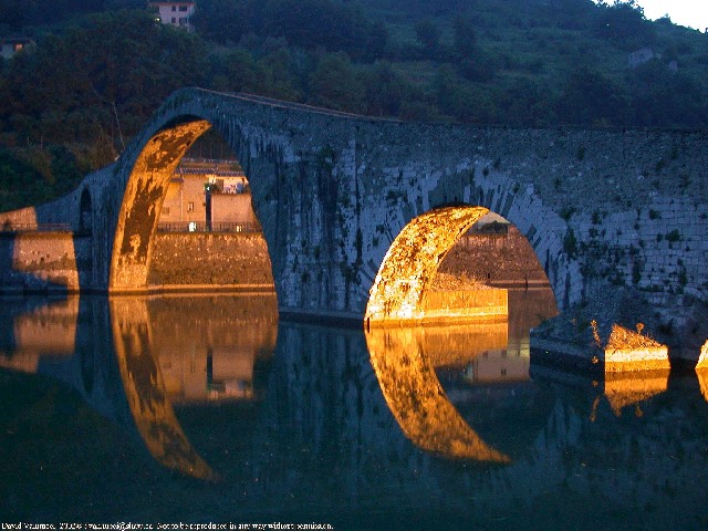
(3) Borgo a Mozzano (where you will see the very pretty 1000 year old Devil's Bridge),
(4) at Calavorno (just after where the road to Bagni di Lucca and Abetone branches off down the Val di Lima to the right).
So after the bridge at Calavorno you must be on the left bank. Take the
third turning on the left after that - which is signposted (amongst many other places) to Fabbriche di
Vallico and Vallico Sotto. This is an isolated side valley off the Serchio heading into the
Apuan Alps where nobody ever goes apart from locals, and you. All the
roads from now on are single-track for long periods - watch out for
traffic coming the other way. The road winds up into the mountains past a
lake and several tunnels for about 9km before you reach the small town of
Fabbriche di Vallico. Just before the centre you need to take a right hand
switchback signposted to Vallico Sotto. From then on there is a very windy
single
track road heading up the valley wall and ever higher into the mountains.
After about 3 km the road flattens out and you will see Vallico Sotto in
front of you (and Vallico Sopra far above, reached by a junction to the
left). The right fork descends into Vallico Sotto.
There are three parking options: (1) on the left of the road descending into
Vallico - which is the second best option if the main car park is full, (2) in the main car park immediately after the road passes through a narrow gap between two houses,
(3) at the entrance to above mentioned car park, there is a very steep
small road descending downwards - this goes to the unpopular "new car
park". This is so far downhill that there is a steep climb to get out of
it - either on foot or for your poor little car. If overburdened with
luggage this is a bad idea as you have to climb a lot anyway.
Vallico is built on a slope and the Towler Institute is the topmost
building in it. So you need to ascend on foot through the village, and
there are three distinct paths - basically keep going up until you find
it. The path on the left - reached from the back of the main car park - is
very steep but goes straight to the Institute if you keep going up. The middle path and the
right path (which both have their origin in the church square immediately after you pass
through the main gate) both end up in a tiny piazza. This
appears to be a dead end, but in fact you can pass through an archway
under the house at the back and you will then find yourself in
Orto dei Gelsi ('The Vegetable Garden of the Mulberry Trees'), from where you
can see the front door of the Institute. Look for the large church building
with a cross on the front.
Enjoy your stay!
|
